Regional
Exploration
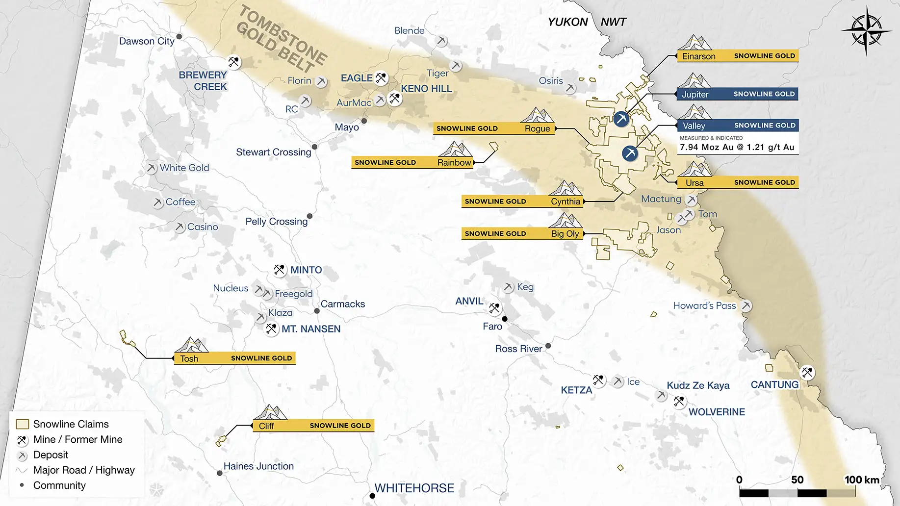
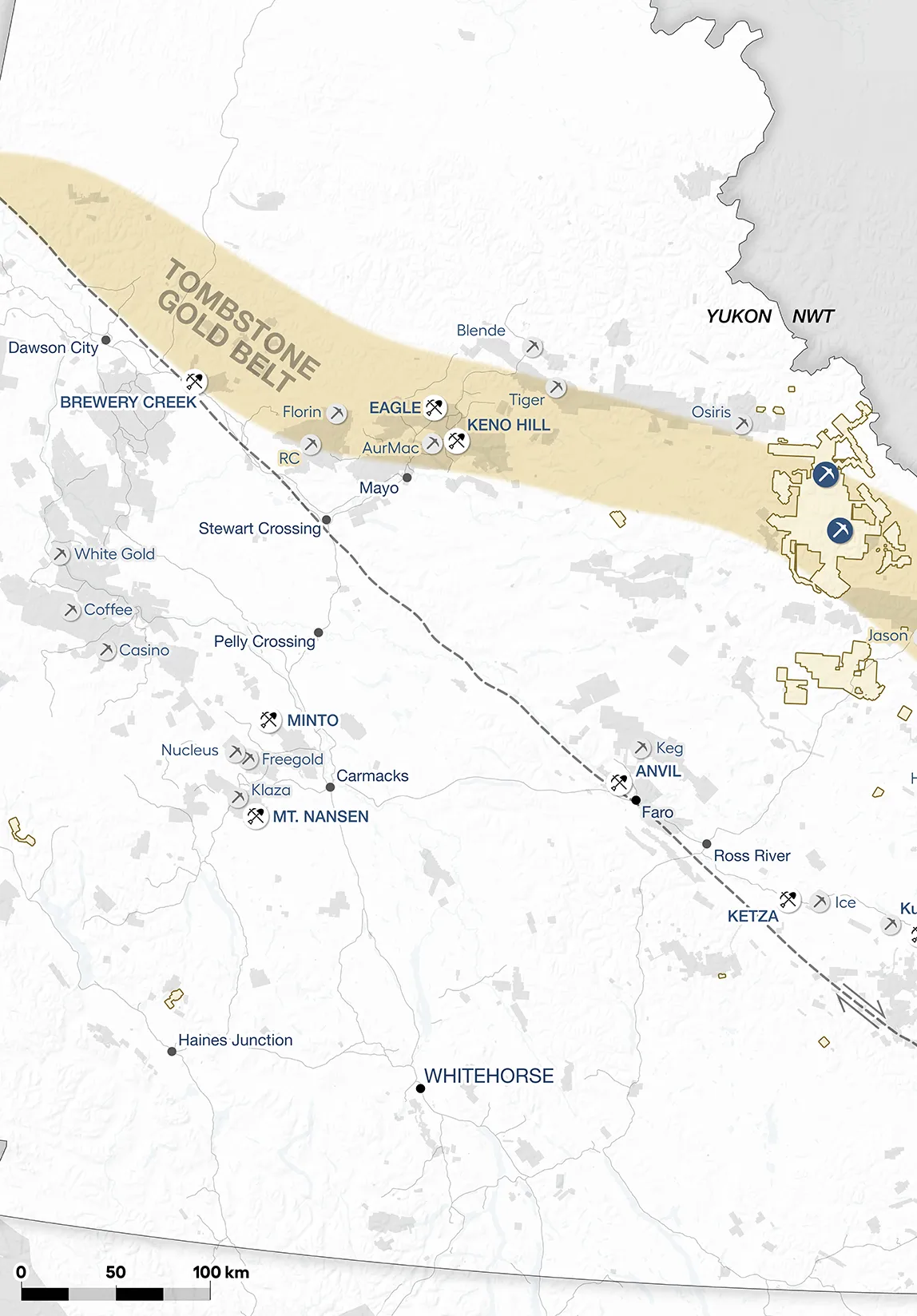
Snowline Gold’s 100%-owned, flagship Rogue Project, in Canada’s Yukon Territory, covers a 60 x 30 km cluster of intrusions in the eastern Tombstone Gold Belt known as the Rogue Plutonic Complex.
Project Overview
Click on a project dot to learn more
Einarson
The Einarson property is a large, underexplored gold project in Yukon’s Selwyn Basin, covering 61,690 hectares across two main claim blocks and several satellite groups. It hosts kilometre-scale geochemical anomalies tied to thrust-faulted domal uplifts of carbonate–siliciclastic rocks, prospective for Carlin-type gold deposits. Additional structurally controlled quartz veins have returned grab samples up to 34.2 g/t Au.
Unlike the nearby Nadaleen trend (10 km away, discovered by ATAC Resources in 2010), Einarson’s geological units are more flat-lying, though still structurally prepared by tectonic shortening, making it a compelling but geologically distinct target for gold exploration.
Rogue
Snowline Gold’s Rogue Project in Yukon’s Tombstone Belt has quickly grown into a flagship discovery. Since 2021, the Valley deposit has advanced to a bulk-tonnage resource of 7.94 Moz M&I at 1.21 g/t Au and 0.89 Moz Inferred at 0.62 g/t Au, making it one of the most significant recent gold finds in Canada. Valley is a reduced intrusion-related gold system (RIRGS), geologically similar to Kinross’s Fort Knox but with notably higher grades, hosted in sheeted quartz veins carrying gold with bismuthinite and tellurides.
The broader Rogue Project spans a 60 x 30 km cluster of intrusions with widespread gold anomalies in soils, rocks, and streams. Given the tendency of RIRGS deposits to occur in clusters, Snowline views Rogue as having district-scale potential for multiple discoveries beyond Valley.
Ursa
The Ursa property in Yukon’s Selwyn Basin hosts a 9 km gold trend in folded black shales, interpreted as similar to Russia’s 67 Moz Sukhoi Log deposit, and a parallel 14 km base metal trend with high zinc (up to 3.4% Zn) plus silver, copper, nickel, and molybdenum.
With geology comparable to world-class Selwyn Basin districts, Ursa shows strong potential for both gold and base metal discoveries. Snowline’s 2021 work focused on sampling, mapping, and prospecting, with follow-up geophysics, trenching, and drilling planned.
Cynthia
The Cynthia property (4 km²) sits between two Cretaceous Tombstone intrusions, with gold mineralization controlled by major faults. Surface samples grade up to 16 g/t Au, and 2010 drilling returned 1.2 g/t over 6.5 m within 0.43 g/t over 32 m.
Intersecting structures host quartz veins, stockwork, and breccias with multi-stage gold mineralization, showing potential for both bulk-tonnage and high-grade deposits. Planned work includes mapping, core review, drone surveys, and geochemical sampling to refine drill targets.
Olympus
TBA
Rainbow
The Rainbow project hosts a gold and pathfinder element soil anomaly linked to a mid-Cretaceous Tombstone Plutonic Suite intrusion, part of the prolific Tintina Gold Belt (home to deposits like Fort Knox and Eagle). Soil sampling outlined a 1 km x 300 m gold zone (to 1.27 g/t Au) with bismuth, tellurium, and tungsten, flanked by arsenic, antimony, and silver anomalies.
The anomaly aligns with the edge of a 3 x 2 km magnetic feature, with rock samples grading up to 7.98 g/t Au. Together with stream geochemistry anomalies 2.5 km away, results suggest a large mineralizing system. Planned work includes drone surveys, geochemistry, and structural mapping to define drill targets.
Tosh
The Tosh Project in Yukon’s Tanana terrane shows strong potential as an orogenic gold camp, in the same geologic province that hosts Newmont’s Coffee deposit and the Klondike’s 12.5 Moz placer gold. Regional faults cut nearby intrusions, providing favorable structural settings for gold mineralization.
Soil sampling (1,379 samples) defined two 2 km-long gold zones, Peska and Koose, with assays up to 5.8 g/t Au and open along trend. Rock samples returned up to >100 g/t Ag and >1 g/t Au in 14 of 66 samples. Historic geophysics at Peska suggests a 500 m conductive structure linked to mineralization. Located 20 km from the Alaska Highway, Tosh is well-positioned for exploration, with upcoming work aimed at refining drill targets.
Cliff
The Cliff Gold Project in Yukon’s Ruby Range targets orogenic gold in rocks similar to Alaska’s Juneau Gold Belt (>7 Moz Au). Soil and talus sampling outlined a 1,600 x 300 m anomaly averaging 179 ppb Au with highs to 3.1 g/t Au, plus a float sample at 7.3 g/t Au. High-resolution drone imagery indicates NW-trending structures that may control mineralization, with follow-up work planned.
Beyond the main Cliff zone, three additional targets were staked in 2021: Hi (1.4 km anomaly with soils to 6.8 g/t Au), Strike (1.5 x 1.5 km gold-arsenic anomaly to 1.26 g/t Au), and Spruce (stream and soil samples to 0.5 g/t Au). The project benefits from nearby infrastructure, including placer roads, a 30 MW hydro station (34 km), and the town of Haines Junction (40 km).